PakAlumni Worldwide: The Global Social Network
The Global Social Network
Volunteer Programmers Contribute to Google Maps For Pakistan
"From Petaluma to Peshawar, these amateurs are arming themselves with GPS devices and easy-to-use software to create digital maps where none were available before, or fixing mistakes and adding information to existing ones", said the NY Times, referring to the volunteer mapmakers contributing to digital maps offered by Google, OpenStreetMaps and others. While both Google and OpenStreetMaps are community created, the main difference between the two is that OpenStreetMap provides its map data under a Creative Commons license and the maps created by users of Google Map Maker are the intellectual property of Google.
Open Street Map (OSM) is a geo project that lets anyone update it. Volunteers donate time and energy uploading GPS tracks, building supporting software, and editing the core data. OSM is growing quickly. As an open data project, OSM makes its data freely available to anyone. This enables custom mapping applications like the OSM Cycle Map. It is also being used commercially by a real estate site Nestoria and by VC-funded startup Cloudmade.
Google Maps has varying levels of coverage of the entire globe (as do its competitors like Microsoft Bing Maps and Yahoo! Maps). Most of the data that is used by Google Maps and displayed comes from Tele Atlas (owned by TomTom) and NAVTEQ (a wholly owned subsidiary of Nokia). More than year ago Google released the ability to move addresses or add a new place. With this feature any logged in user can make an edit; you can even watch the edits in a realtime viewer. If your change is accepted it will show up in Google Maps. Road geometry and address changes derived from Tele Atlas data will be sent back to Tele Atlas to help improve its information. The updated data will eventually make it into new-owner Tomtom's GPSs and potentially Google's competitors who also use Tele Atlas. The data collected via MapMaker will not be shared with Tele Atlas.

Google is gradually dropping its dependence on the traditional commercial map vendors like TeleAtlas and Navteq. Instead, it is relying on unpaid volunteers to create digital maps of 140 countries, including India, Pakistan and the Philippines, that are more complete than many maps created professionally. One such volunteer mentioned in the NY Times story is Faraz Ahmad, a 26-year-old programmer from Pakistan who now lives in Glasgow, Scotland. He took one look at the map of India and decided he did not want to see his native Pakistan left behind by its traditional rival. So he began mapping Pakistan in his free time, using information from friends, family and existing maps. Faraz Ahmad is now the top contributor to Google Map Maker, logging more than 41,000 changes.
India-Pakistan rivalry took on a new dimension when Faraz tried to work on Azad Kashmir, and he found that Map Maker wouldn’t allow it. He said his contributions were finally accepted by the Map Maker team, which is led by engineers based in India, but only after a long e-mail exchange.
At his request, Google is now preventing further changes to the disputed region, after people in India tried to make it part of their country, Faraz told the NY Times. “Whenever you have a Pakistani and an Indian doing something together, there is a political discussion or dispute.”
In addition to Faraz, there is a whole community of Pakistani volunteer programmers and mapmakers currently adding roads, streets, businesses, crossings and various points of interest (POIs) for areas for which there are no maps defined yet. Then other users approve or disapprove the additions and changes. Eventually, the maps are posted to Google maps and Google maps mobile. Fairly detailed Google maps for mobile are available today for Pakistan. Such searchable, navigable and routable digital maps are expected to help grow real estate, travel, transportation, retail, financial services, healthcare and emergency services and other service sectors.
The reason why mobile maps have come first is because of the large user base of about 80-90 million mobile phone subscribers. Pakistan has a vast data network over GSM/GPRS/EDGE and EVDO and there are no alternative street navigation systems, with the exception of fairly expensive car navigation systems costing tens of thousands of rupees. Google has a database of cell Towers in Pakistan, and with the help of these towers it identifies the location of the user in real time, within about 10 to 20 meters and sometimes up to 3000 to 4000 meters, depending upon the density of cell towers in a given area. If the mobile phone has data service enabled, the user can download the Google mobile map application from m.google.com/maps. After downloading the application and installing it, it is available in the applications folder of the mobile phone.

A number of GPS enthusiasts have also developed Garmin compatible navigation maps for Islamabad, Lahore, Karachi, Peshawar and a few other cities in Pakistan. But it's rare to see car navigation systems in Pakistan.
As painful as it is to watch the constant media coverage of blood and terror in the streets of Pakistan, the NY Times story of volunteer cartographers and the recent Karachi Fashion Week illustrate that there is more to Pakistan than meets the eyes or reaches the ears of the passive consumers of the western and Pakistani news media.
I am glad that there are enough volunteer programmers and amateur cartographers in Pakistan to attempt to build detailed digital maps and maintain them in their spare time--without the assistance of commercial vendors like Tele Atlas and Navteq who did the same for North America and Europe at huge costs. The main contribution of the government under President Musharraf was to invest in the growth of the telecommunications, higher education, and the Internet infrastructure, a pre-requisite for online volunteer collaboration in projects such as map making. It shows what the Pakistani people are capable of doing with just a little help, in spite of the continuing institutional failures in Pakistan. As I have said before, and I repeat here again, it is better to light a candle than curse darkness.
Here's a video clip explaining Google Maps for mobile:
Related Links:
Life Goes On in Pakistan
Pakistan's Multi-billion Dollar IT Industry
Routable Maps of Karachi, Pakistan
Online Maps: Everyman Offers New Directions
Mapping Pakistan
Digitizing Pakistan
Google Maps Come to Pakistan
EVDO Pakistan
GPS Automotive Navigation in Pakistan
SatNav in Pakistan
Pakistan Cartography Wiki Project
Light a Candle, Do Not Curse Darkness
Views: 1830
-
Comment by Riaz Haq on September 10, 2012 at 2:54pm
-
In addition to adding $500 million to Google's revenue, young Pakistanis are making significant voluntary contributions to Google offerings like Google Maps. This has attracted the attention of Google bosses like Eric Schmidt who recently visited Pakistan and described Pakistan's young demographics as a great asset.
http://www.riazhaq.com/2009/11/online-digital-maps-petaluma-to.html
Here's an ET report on Google in Pakistan:
Google earns an estimated $500 million in revenues from its users in Pakistan, about 1.3% of the firm’s global total, according executives at Google Pakistan, who held their first ever public event in the country to highlight the technology giant’s interest in the country.
“Pakistan is Google’s next big market in the region,” Google’s head of Emerging Market Development, Southeast Asia, Jana Levene told a gathering of IT experts, bloggers, businessmen and selected journalists at Pearl Continental hotel in Karachi on Monday.
The gathering comes after Google’s executive chairman Eric Schmidt visited Pakistan in June to meet with the country’s politicians and businessmen. “It was just a regular visit. He wanted to find out how important the use of technology for the country’s leadership and businessmen is,” said Badar Khushnood, Google’s consultant in Pakistan.
Moreover, Google has intensified its operations by getting involved in a lot of projects – especially with the Punjab government – in the country recently. “Innovation Punjab” is one example where Google has partnered with Punjab Information Technology Board. It has launched a social innovation fund – in collaboration with Pakistan Software Houses association, also their partner for the event – to support young entrepreneurs struggling to get their ideas public.
Google’s increased interest in the country, Schmidt’s visit of Pakistan and now this event sends very strong signals to the country – the giant may consider opening an office in Pakistan. Khusnood denied if Google was opening its first office in the country anytime soon but added it couldn’t be ruled out. Google’s representatives attributed Pakistan’s growing importance to multiple factors.
“To enter a market, the first thing we look at is its demographics – number of internet users in that country,” Jana Levene said, explaining why Google is interested in Pakistan. “Twenty-two million internet users is a huge number. It’s more than Australia’s whole population. That’s why we are here,” she said.
The second thing Google is interested in, Levene said, is the size of the market. “Pakistan is a $400 to $500 million market for Google,” she said. Currently, four of the top 10 most popular websites in Pakistan are Google’s sites.
---------
But the key takeaway from the event was not the information, but the fact that it was addressed by six senior Google executives, a strong indication that the technology giant wants to expand further in the Pakistani market.“We are calling you to help us bring more Pakistanis online,” Jana Levene said addressing country’s leadership as well as the technology sector. “Tell the world Pakistan is economically viable. It’s a safe place to do business,” Levene said.
http://tribune.com.pk/story/434461/up-and-coming-google-pakistan-ea...
-
-
Here's a piece on proposed Pak legislation to ban private maps:
The government of Pakistan is about to propose a law that would make it illegal for independent bodies to engage in mapping. The Land Surveying and Mapping Bill 2012, proposed by the Ministry of Defence (MoD), transfers all mapping authority in Pakistan to Survey of Pakistan (SoP), which reports to the MoD and takes its orders from General Head Quarters (GHQ).
SoP is the national organization responsible for surveying and mapping requirements of the Armed Forces and civilian departments — in that respect, at least, its origins are similar to those of the United Kingdom's Ordnance Survey. Over the past decade, however, the advent of computer-aided cartography and the availability of satellite imagery have radically changed the realm of maps and Geographic Information Systems (GIS). Easy access to this kind of technology has helped individuals and organizations to support their own efforts at social and relief work.
For instance, after the floods of 2010 that devastated huge swathes of the country, relief workers created and used their own mapping resources to allocate aid efforts more effectively, thus saving many lives.
This year Umar Saif, MIT Technology Review’s Innovators Under 35 award winner, used mapping technology to detect the spread of Dengue fever in Lahore. Early detection prevented the virus from becoming an epidemic.
The Punjab government initiated an Innovation Punjab campaign with the help of Google. The campaign brings inexpensive Internet access to rural youth, with the goal of empowering the next generation of tech innovators.
During the 2010 crisis, several NGOs and relief workers mapped information using Ushahidi. If the proposed bill is passed, Google Maps and Ushahidi would be banned from Pakistan. All the hard work invested by local and international relief workers, volunteers and organizations would be in vain.
The MoD's position is that in the absence of a national law and regulatory authority for mapping, it is impossible to keep a check on unlawful activities — especially in sensitive areas. They claim that the purpose of the poposed bill is to limit potential risks to sensitive information — to prevent duplicate mapping, which they say would be a financial burden for the state and to transform the SoP into a national mapping agency. Since mapping data can be obtained easily from non-governmental sources, this undermines the logic of the MoD's case. There is also the question of whether a ban on mapping can prevent "unlawful activities in sensitive areas."
Online maps and satellite imagery, GPS-enabled devices and in-car navigation are all easily accessible in Pakistan.
If the bill passes in to law, the SoP will be the regulatory body controlling all mapping activities. Any other body wishing to create a map will have to apply for permission to do so — and can expect to have their activities and their outputs controlled as a result.
The bill also assigns responsibility for various parts of the mapping infrastructure (such as survey markers) to regional and district administrative bodies. Those who remember the woeful ineffectiveness of those bodies during the floods of 2010 may wonder whether such a transfer is either wise or practical. In addition to installing itself as the single point of control for all mapping activity, the MoD will also delegate to the Pakistan Army responsibility for enforcing the bill.
Thus, we have the MoD undertaking to do something it did not do before, the local administrations having to do things they did not do before, and the Army having to keep track of it all on the ground. ....
http://techpresident.com/news/wegov/23188/pakistan-considering-bill...
-
-
Here's a News story on FBR trying to tax Google ad revenue in Pakistan:
KARACHI: The Federal Board of Revenue (FBR) is devising ways to tax internet search engine Google Inc on the revenue generated through its business in Pakistan, said sources.
“It is difficult to levy taxes on the Internet search engine as it has no permanent establishment in Pakistan,” said a tax official. “However, since revenue is being generated through local advertisements, local departments have the right to collect tax under this head,” said official.
Google Inc is an American multinational corporation, providing Internet-related products and services, including internet search, cloud computing, software and advertising technologies around the world.
The recent discussion in the FBR on taxing the foreign company came in the limelight following the reports that Indian taxation authorities had issued notices to Google Inc for tax evasion. The Economic Times of India on November 13 reported that Google India had been slapped with a fine of 760 million Indian rupees ($13.8 million by the country’s income tax authorities).
The daily also reported search giant’s Indian arm had misled the department, under-declared its income, violated accounting rules and attempted to underreport revenues.
“The FBR chairman has instructed the tax departments to identify the business activities of the company in Pakistan,” said another FBR official. “So far, the FBR headquarters has not assigned the job to any tax department,” said official.
The authorities are finding agents working on behalf of Google Inc in Pakistan to inquire about the permanent establishment of the company and to assign jurisdiction to a tax department.
The official, however, said that in this case there is a possibility that the United States might express reservations as the two countries have an agreement regarding double taxation.
The authorities admitted that online commercial transactions have become sophisticated and tax departments have failed to generate tax revenue from such activities.
According to media reports, Pakistani advertisers spent Rs32 billion on advertisement in the print and electronic media in 2010-11, in which one percent of amount went to Internet advertising.
It also reported that Google accounts for 35 percent of total online advertisement spending.
Google officials on the condition of anonymity said that Pakistani authorities have no jurisdiction to tax the international entity.
About withholding tax by local advertisers, they said, big vendors pay the tax through proper invoices, while small vendors made transactions through credit cards and other means.
http://www.thenews.com.pk/Todays-News-3-145443-FBR-devising-ways-to...
-
-
On this uneven landscape (averaging two years of quarterly data from 2010-2011), Israel produced almost as many edits (215,333) as the rest of the region put together (254,089).
Graham and Zook have also tried to measure information density in the geoweb by looking at what Google indexes about a place (after all, this is Google’s mission statement: to "organize the world's information and make it universally accessible and useful"). The process is a bit meta. "We just ask Google Maps how much it knows about any particular place," Graham says, "and it returns that information." The researchers essentially set up a computer script that visits hundreds of thousands of points on the world’s surface, conducts a search for indexed content related to that point on Google, then stores the results in a database.
"By aggregating all of that data," Graham says, "we can see interesting patterns about which parts of the world people are looking at and which parts of the world people aren’t looking at it."
The results show, for instance, that the Tokyo metropolitan region is more densely layered with digital content than all of Africa. This is a map of the world sorted by the density of information indexed by countries on Google Maps:
 "Augmented realities and uneven geographies: exploring the geolingui...," Graham and Zook in Environment and Planning.
That picture raises the old question posed by those 19th century maps of Africa: What happens to the people who aren't on the map, or who are barely represented at all? "What I worry is that what this will start to do is simply reinforce the divides and the differences between the haves and the have-nots, the cores and the peripheries," Graham says. “It’s most worrying for the places that are essentially off the map – or not in the database.”
Think, for example, of a sandwich shop in a Detroit neighborhood on the other side of the digital divide that has no website, no Yelp reviews, no little red balloon on Google Maps. How do people find it? Surely this form of invisibility is bad for business. Graham offers up another example from his own research in East Africa, where he has studied how the Internet has impacted the tourism industry. He interviewed a Kenyan tour operator about why he recently started offering trips to Rwanda.
What this will start to do is simply reinforce the divides and the differences between the cores and the peripheries.
"He told me he Googled it. He Googled ‘gorilla tours, Rwanda,'" Graham says. The tour operator was pleased that Google enabled him to learn about new places and, as a result, to offer them to his customers. But of course Google doesn’t really generate information; it directs people to it. And so, as Graham pressed further, it turned out that the man was ultimately deriving his information from Wikipedia.
"This is obviously just one example, it’s an anecdote, but I think in a very real way that was sort of shaping the flows of capital and people over quite large distances between Europe, where they were coming from, and Kenya, and then Rwanda,” Graham says, "simply because someone had written a Wikipedia article about that place and not another place."
Graham often circles back to that example when he’s thinking about what it might mean for a place to not be represented, either in peer-produced information on the Internet or in the algorithms that sort it all. This happens at the national level, with inequalities emerging between countries and regions. But it also happens within cities at the scale of neighborhoods. Zook has conducted other research illustrating the disparities in information layered over racially segregated parts of New Orleans. And we can see similar patterns – sometimes deceptive ones – emerged in the tweets from New York City during Hurricane Sandy. During the storm, the densest quantity of Sandy-related tweets emerged from Manhattan, relative to other boroughs of the city. But that doesn’t mean that Manhattan suffered the worst damage; rather, that it often produces the largest quantity of data. It’s easy to conflate the two, though, which is why maps often equate with power.

All of this information, Graham stresses, doesn’t exist in some kind of virtual world that's separate from the real one. The two are intimately intertwined: We use digital information to navigate and understand the physical world, and in turn our experiences of place impact how we then contribute to the information about them. When we use this information (by, for example, clicking on a restaurant on Google Maps), we are often simultaneously consumers and producers of it (that single click is another data point in Google's vast machine). All of this means that the geoweb may not just be reinforcing real-world inequalities. In many ways, it’s also enabling us to have dramatically difference experiences of the same places.
Consider this last example from Graham and Zook’s latest research: They conducted Google searches for the word "restaurant" in Tel Aviv, in three different languages. This is the picture that turns up from the English-language search:
 Google Maps
http://www.citylab.com/tech/2013/02/how-internet-reinforces-inequal...
-
-
Pakistan URINE STORM: Google Maps chokes off user editing
Choc Factory calls for a rethink in pisstake mistake
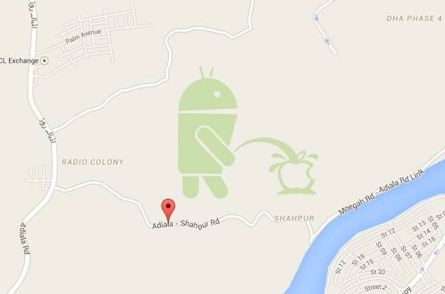

From Tuesday, Google is cutting user edits from its Maps after admitting that it simply can't prevent online tricksters from abusing the system.
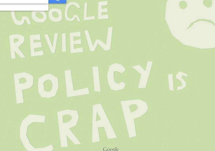
A much less creative attempt, although more to the point
Last month, the firm was forced to make some quick edits after a user noticed that someone had created a mythical park in Pakistan in the shape of the Android mascot robot relieving itself over an Apple logo. Another user spotted a similar bit of graffiti proclaiming "Google review policy is crap," and the firm has now decided to take action.
"A strong user in our community chose to go and create a large scale prank on the Map," said Pavithra Kanakarajan from the Google Map Maker team in a forum post.
"As a consequence, we suspended auto-approval and user moderation across the globe, till we figured out ways to add more intelligent mechanisms to prevent such incidents. All of our edits are currently going through a manual review process."
While manual editing appears to be solving the problem there's no way Google's engineers can keep up, he explained, and any new edits were just adding to a backlog of things that need to be checked. So no more edits will be accepted until Google has worked out how.
"While this is a very difficult, short term decision, we think this will help us get to a better state faster," Kanakarajan said. "More importantly, we believe it is simply the right thing to do to all of you, our valued users who continue to edit with the hope that your changes might go live as fast as you've been used to."
Plus it saves on embarrassing headlines, too. Kanakarajan didn't specify a deadline for resuming edits
http://www.theregister.co.uk/2015/05/11/google_kills_off_maps_editi...
-
-
Google to introduce 'Street View' for #Pakistan's cultural sites. Moen Jo Daro Taxila Makli Shalimar http://www.dawn.com/news/1201938
Google announced on Thursday that it would be introducing panoramic imaging for over a dozen historical landmarks in Pakistan, similar to its Street View offered in other countries.
The tech giant announced the launch of the project to highlight and promote Pakistan’s rich cultural heritage.
Google has undertaken the project in collaboration with a number of local non-profit organisations which include the Citizens Archive of Pakistan (CAP), Mohatta Palace Museum, Heritage Foundation Pakistan, and others.
Currently there are a total of six locations listed on the World Heritage List by the United Nations Educational, Scientific, and Cultural Organisation (UNESCO). It is reported that all of these sites will be included in Google’s new project.
Some of the sites that will be included in the panoramic view will include the ruins of Moenjodaro, Rohtas Fort and Shalimar Gardens and Fort.
This is not the first attempt by Google to promote Pakistani culture. Earlier in 2012, the tech-giant had signed an agreement with the provincial government of Punjab to capture historical locations and cultural sites.
The current project is more encompassing, as it includes cultural and historical sites from across the country.
Pakistan is blessed with a rich and diverse cultural lineage. The origin of the current Pakistani culture can be traced back to the Indus Valley civilization, which existed around the same time period as the Egyptian and Sumerian civilizations.
The current land mass which constitutes Pakistan has been influenced over the centuries by the arrival of Greek, Aryan, Buddhist, Arab Muslim, Mughal, Hindu and Christian cultures.
-
-
#Google launches turn-by-turn voice navigation for #Android #smartphones in #Pakistan http://tribune.com.pk/story/1065925/google-launches-turn-by-turn-na... …
Google has finally launched its turn-by-turn navigation system for Pakistan allowing users to get directions for a selected route in the form of vocal and visual instructions.
The feature is currently only accessible for beta users and can be accessed on any Android phone.
Based on real-time location, the navigation system will now enable users to get automatic guidance and turn-by-turn details through voice commands.
Take a look at the world’s secret sites on Google Earth
The previous system available on Google Store had only the basic features with an automated voice guidance missing. With a vast improvement to the new app, the phone screen will remain lit after navigation is launched and voice guidance will also alert users about upcoming turns and traffic.
Should the user make a wrong turn, the navigation system will automatically alert the driver. Although this feature is already in place in many countries, it is new for Pakistan.
Google Maps guides travellers offline
Users can download the latest software from Google Store which will be activated with any internet connection or WiFi.
Motorists believe this new feature could be extremely useful and could guide users about real time changes in routes and traffic — a major breakthrough for the country.
-
-
Cartographers beware: #India warns of $15 million fine for maps it doesn't like. #Kashmir #Pakistan #China #Modi
https://www.washingtonpost.com/news/worldviews/wp/2016/05/06/cartog...
Let's start with a basic fact: India claims much more land than it controls.
Thus, any map of India and its neighbors makes an inherently political statement based on how it depicts their borders. The issue is particularly thorny because the border disputes are with India's great rivals: Pakistan and China.
On Thursday, a draft law reflecting India's sensitivity over maps was uploaded by the government online before being swiftly removed for reasons unknown. The draft law would define how India's international borders are drawn once and for all, and punish offenders with up to seven years in jail or fines ranging from $150,000 to $15 million. It would also require all individuals and companies producing maps in India, and all Indian citizens doing so globally, to procure a license from the government.
Pakistan and India both claim jurisdiction over the entirety of Jammu and Kashmir, an area that spans fertile plains, lush foothills, towering Himalayan mountains and the alpine barrens of the Tibetan Plateau. It is also the theater of India and Pakistan's defining conflict, which has led to three wars and once brought the subcontinent surprisingly close to the verge of mutual nuclear annihilation. Both nations occupy parts of Kashmir and station hundreds of thousands of troops there, mostly along the incredibly tense Line of Control (LoC) that serves as the de facto border.
China also claims — and controls — a sizable chunk of (what was once) Kashmir known as Aksai Chin, which it subsumed after handily defeating India in a 1962 war. The border there is slightly more definitive, which is reflected in the name India uses for it: the Line of Actual Control (LAC). China also claims almost all of another Indian state called Arunachal Pradesh, which stretches between Bhutan and Myanmar. China refers to it as "South Tibet." India administers the state, and Chinese incursions are very rare.
The map that India wants the world to see, of course, bestows it all these disputed regions. If it actually becomes law, it would certainly complicate the operations of technology companies that rely on maps, such as Google and Uber. Already, Google shows different borders to users in different countries. From the United States, India's disputed borders are shown on the website as dotted lines.
-
-
#Pakistan’s first homemade #Digital Mapping Solution to be launched. #Telenor
http://www.brecorder.com/pakistan/business-a-economy/296973-pakista...
Telenor Pakistan and TPL Trakker have joined hands to introduce Pakistan’s first homemade digital mapping solution.
According to local media reports, a Memorendum of Understanding (MoU) has been signed between the two tech firms, under which TPL Maps has been launched. “TPL Maps has been created using state of the art technology that will not only provide real time intelligent routing but also give users access to live traffic updates, turn-by-turn navigation and smart search options,” said the app description on Telenor Apps.
The app features smart search option that has over 1.35 million Points of Interests (POIs) which allows users to reach their desired destination by choosing the POIs from across Pakistan. The homemade TPL Maps covers over 500 cities and 800,000 distinct housing addresses, which are spread over a road network of 280,000 km.
Whereas, the Pakistani made TPL Maps also includes 2D models of over 55,000 POIs which helps users identify and reach their desired location in the shortest time period possible.
“We have developed Pakistan’s first comprehensive digital mapping solution via Pakistani talent and resources because we believe a localize, in depth mapping solution for Pakistan will define the future of digital payments, ecommerce, 3G/ 4G and social networking activities. TPL Maps, equipped with smart features, will offer services that will change the future of consumer behavior, navigation, distribution process management, advertising and many other areas alongside navigation and maps related services,” said Ali Jameel, CEO TPLTrakker.
The maps app allows any smart phone carrier to choose the best route on the back of latest navigation technology and thorough traffic information, which provides accurate, real-time traffic information from over 200,000 GPS equipped vehicles.
-
-
Google Maps #Pakistan Rival TPL Trakker to Expand in Three Countries: #Bangladesh #Iran #SriLanka http://bloom.bg/2csgtw1 via @markets
Pakistan’s largest tracking service provider is planning to expand its mapping service to Bangladesh, Iran and Sri Lanka within three years to cater to the under-served countries with a combined population larger than Eurozone.
“My short-term objective is not to look at maps just for Pakistan, but for all areas where people are not active,” TPL Trakker Ltd. Chief Executive Officer Muhammad Ali Jameel said in an interview in Karachi. “We will become a significant player in the mapping space.”
The company, which rivals Alphabet Inc.’s Google map business, is aiming to make its app one of the most frequently used mobile applications by providing services such as food delivery and e-commerce. Started in Pakistan last month, TPL’s maps will begin generating revenue in six months. The application will be free for users with the company planning to sell advertisement space.
“The objective is to have world class maps and have data that is semi-local, but will have better quality than anybody else,” said Jameel. “The objective is to get people hooked onto the maps because of the features.”
TPL Trakker’s stock rose 2 percent, the most in a week, to 12.3 rupees at close in Karachi on Friday. Shares have fallen 17.6 percent this year, compared with a 21 percent gain in the nation’s benchmark index.
Navigation System
The company also supplies maps to cars sold by Toyota Motor Corp.’s Pakistan unit as part of its navigation system. TPL plans to add the service to another automobile company by June, Jameel said. The company is seeking to boost revenue to as much as 12 billion rupees ($114 million) in four years from 2 billion rupees, he said.
Google Maps which started over a decade ago as a desktop mapping service has become one of the search engine’s most-used smartphone global app products offering satellite imagery and street maps. The market leader provides live traffic data in 60 countries and constantly adds newer features customized to each location.
The U.S. company has run into hurdles with authorities of some nations. Google’s camera-mounted cars were to roam Indian cities collecting imagery from roads and public locations for its free Street View service but the nation’s Home Ministry rejected plans in June. Indian security agencies have expressed apprehensions as the country has had multiple terrorist incidents with attackers extensively photographing targets in advance.
“Mapping is a sensitive business,” says Jameel. “It’s a sensitive business that is not regulated but can be regulated.”
Jameel got permission earlier this year for Pakistan after applying eight years ago with the government’s mapping organization called Survey of Pakistan. The group also plans to start construction of a high-end residential building in Pakistan’s commercial capital in January after listing its property business, which includes an office building that fetches the highest rent in Karachi, according to Jameel. Property prices have more than doubled since 2012 in the coastal city that’s recovering from decades of sectarian violence, bombings and kidnappings.
Comment
Twitter Feed
Live Traffic Feed
Sponsored Links
South Asia Investor Review
Investor Information Blog
Haq's Musings
Riaz Haq's Current Affairs Blog
Please Bookmark This Page!
Blog Posts
Pakistan Electricity Consumption Up 21% in Just Two Years
Pakistan is experiencing soaring demand for electricity across all of the sectors of its economy. The new demand is being met by rapidly growing deployment of distributed solar, estimated at 38 GW as of June, 2025. In 2025, 44% of solar deployment was residential, followed by industry (26%), agriculture (21%) and commercial users (9%). The expansion of distributed solar has enhanced electrification across the economy, lifting Pakistan's electrification rate to 21.7%…
ContinuePakistani-American Professor Publishes Landmark Genomic Research on Pakistanis
Dr. Danish Saleheen, a Pakistani-American professor at Columbia University, and his fellow researchers have published a comprehensive analysis of 173,303 genomes from Pakistan, one of the largest genomic studies ever conducted in South Asia. This landmark work is upending how scientists understand human genetics and drug development. "South Asians have been severely underrepresented in genome studies—comprising just 2% of global genomic databases despite representing…
Continue
© 2026 Created by Riaz Haq.
Powered by
![]()
You need to be a member of PakAlumni Worldwide: The Global Social Network to add comments!
Join PakAlumni Worldwide: The Global Social Network