PakAlumni Worldwide: The Global Social Network
The Global Social Network
Is Climate Change Rapidly Shrinking Pakistan's Glaciers?
A recent headline in Pakistan's Express Tribune newspaper declared: "Pakistan's glaciers melting faster than rest of the world". A few days later, I heard an ex-Met Department officer in Pakistan repeat the same alarm on a Geo TV show "Capital Talk" anchored by Hamid Mir. Are these people right?
Recognizing it's too important an issue to let go, I decided to look into the facts and data as reported in science journals. Quickly, I came upon "Karakoram Anomaly". I learned that it's a term used to describe the fact that, unlike other mountainous regions, the Karakoram glaciers which supply most of Pakistan's river water are growing rather than shrinking.
|
Baltoro Glacier in Karakoram National Park in Pakistan |
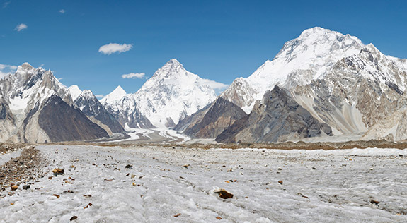
Pakistan is home to the most heavily glaciated area outside the polar regions of the Arctic and Antarctica. The massive glaciers of Baltoro and Biafo stretch for over 60 kilometers each in the Karakoram Mountains, according to Bina Saeed Khan who wrote on this subject in Pakistan's Dawn newspaper in 2013. The area designated as the Central Karakoram National Park in Pakistan has 711 glaciers, which is double the number of glaciers in the Alps in Europe.
A research report published in the journal Nature Geoscience has recently reported that the ice in the Karakoram mountains is sustained by a unique and localized seasonal pattern that keeps the mountain range relatively cold and dry during the summer months.
Other Himalayan ranges and the Tibetan Plateau — where glaciers have increasingly receded as Earth's climate has warmed — receive most of their precipitation from heavy summer monsoons out of hot South and Southeast Asian nations such as India.
 |
| The Himalayas |
The main precipitation season in the Karakoram in Pakistan, however, occurs during the winter and is influenced by cold winds coming from Central Asian countries such as Afghanistan to the west, while the main Himalayan range blocks the warmer air from the southeast throughout the year. The researchers determined that snowfall, which is critical to maintaining glacier mass, will remain stable and even increase in magnitude at elevations above 4,500 meters (14,764 feet) in the Karakoram through at least 2100. On the other hand, snowfall over much of the Himalayas and Tibet is projected to decline even as the Indian and Southeast Asian monsoons increase in intensity under climate change, according to Princeton News.
Understanding what will happen to the Karakoram glaciers in the next several centuries is an existential question for Pakistanis. Pakistan needs to sustain and grow its fresh water resources to support a growing population. WAPDA (Water and Power Development Authority) has recently set up a Glacier Monitoring Research Centre in Islamabad, which intends to conduct mass balance studies of five major Upper Indus glaciers, as well as installing new high-altitude weather stations. The six-year project is funded by the World Bank.
Related Links:
Pakistan's Rising Population: Blessing or Curse?
Recurring Floods and Droughts in Pakistan
Helicopter Skiing in Karakoram Mountains in Pakistan
Climbing K2-The Ultimate Challenge
Extreme Kayak Adventures in Pakistan
Resilient Pakistan Defies Doomsayers
Views: 560
-
Comment by Riaz Haq on July 28, 2015 at 5:10pm
-
The Government of Japan will replace the weather surveillance radar in Karachi with a grant of 1.95 billion Yen (approx Rs 1.6 billion).
For this purpose, Ambassador of Japan to Pakistan Hiroshi Inomata signed and exchanged notes with Economic Affairs Division (EAD) Secretary Muhammad Saleem Sethi on Wednesday. A grant agreement on the details of implementation of the project was also signed between JICA chief representative Mitsuyoshi Kawasaki and EAD Joint Secretary Syed Mujtaba Hussain.
Four (Islamabad, Karachi, Dera Ismail Khan and Rahimyar Khan) out of seven meteorological radar systems in Pakistan were established under the grant of Japan. These four radars observe the precipitation of about 80% of the country. Among them, the existing Karachi radar system established in 1991 has played an important role in monitoring meteorological phenomena in the southern area and tropical cyclones which are formed over the Arabian Sea and the Bay of Bengal.
However, with the passage of time and despite maintenance, the installed radars are losing their relevance to modern technology. In the wake of these imminent challenges, it is pertinent to shift from this analogue system to modern digital Doppler mode radar. The new radar will have a 450km radius of information processing for consumption of the Pakistan Meteorological Department (PMD).
This will help the PMD monitor the movement and development of severe weather systems to prepare more accurate and timely weather forecast and to warn coastal areas in Sindh and Balochistan. Forecast for international shipping and aircrafts’ traffic will also be improved. The Doppler mode is essential in achieving more accurate forecasting and longer forecast prediction times.
This project is the first priority of the National Multi Hazard Early Warning System Plan which was a part of the National Disaster Management Plan (NDMP) formulated through Japan’s assistance in 2012. In accordance with the NDMP, Japan has been extending assistance such as replacement of the meteorological radar in Islamabad and installation of the Flood Forecasting System in collaboration with UNESCO. The project agreed on Wednesday is expected to have synergies with these ongoing and completed projects assisted by Japan.
At the signing ceremony, Japanese Ambassador Hiroshi Inomata expressed the hope that this project contributes to protecting more lives and properties from future natural disasters.
He also said, “Japan will continue to work together with Pakistan to make this country disaster-resilient, making good use of experience and expertise Japan has gained from many disasters in the past.”
JICA chief representative Kawasaki while commenting on the significance of the project said, “Since Japan also has faced persistent natural disasters and overcome it in our long history, Japan should lead and strengthen disaster management in the world based on our knowledge and experience as well as the Sendai Framework for Disaster Risk Reduction which is one of the fruit of the 3rd UN Conference on Disaster Risk Reduction.”
The Government of Japan committed in November 2013 that it would provide 1.6 trillion Yen (approximately $16 billion or Rs 1.4 trillion) of public and private finance over a period of three years from 2013 to 2015 to developing countries, which include Pakistan, to counter climate change. The project agreed on Wednesday forms a part of this commitment.
http://www.dailytimes.com.pk/national/09-Jul-2015/japan-to-grant-rs...
-
-
#Pakistan: An incredible journey to the #glaciers of the #Karakoram | via @Telegraph http://www.telegraph.co.uk/travel/destinations/asia/pakistan/119916... …
----
The (British) group admitted that they had had pre-conceptions about Pakistan, but received "nothing but overwhelming hospitality" throughout their trip. They stressed the importance of seeking out a knowledgeable local guide - "Ali Saltoro of Alpine Adventure Guides was incredible". They added: "The people we met all wanted more visitors to come and see their beautiful country."
They said that the Yushkin Glacier itself was one of the most beautiful places visited: "House-sized blocks of ice, carved into endlessly beautiful shapes and forms by the torrents of crystal clear water, that would suddenly dive into the glacier and disappear, roaring down into its depths."
------
Terrifying roads and inhospitable weather greeted a recent expedition to the mountains of northern Pakistan - but at least the views were spectacular
the (British) team, backed by the Royal Geographical Society, had good reason to be where they were. Home for two months for the group of scientists, geographers and photographer Tim Taylor was base camp on the Yukshin Glacier, below Yukshin Gardan Sar (7,530 m), in the Hispar Muztagh mountains, a sub-range of the mighty Karakorams in the remotest part of the ethereal Hunza Valley in north-eastern Pakistan.
These superlative landscapes were briefly deemed off-limits to British travellers, after a mountaineering group was attacked and 11 killed at the basecamp of Nanga Parbat peak in the same Gilgit-Baltistan region. However, the Foreign Office relaxed its travel advice for the area earlier this year. The terrific geography of the place makes travel difficult all the same. Bad weather meant the group's flight from Islamabad further north was cancelled, forcing them into a 24-hour journey on some of pretty hair-raising roads (see below). The group described the route as "a car width's track cut into the rock hundreds of feet above a roaring torrent of water."
Another obstacle was Attabad Lake - formed when a colossal landslide submerged a village. The only way to get vehicles across it is the work of simple genius: 4x4s are strapped onto wooden planks laid across the back of a tiny boat.
In September, those parts of the Karakoram Highway - the world's highest paved road - destroyed by the Attabad landslide, were reopened, meaning that more conventional forms of transport are making their way back into the region.
The group set out to monitor the deadly phenomenon of glacial lake outburst floods, or "inland tsunamis", caused by the breaching of ice dams that allows water to surge downstream. According to the Karakoram Anomaly Project, the effects of this phenomenon pose a threat to around 80,000 people in the region.
The team collected data that would allow them to predict the risk of a glacial lake outburst flood in the Shimshal Valley. The road to this small village was only finished in 2003, having taken almost 20 years to construct. There are no roads beyond this, meaning that explorations in and around the glaciers were completed on foot.
The work also involved "repeat" photography: recreating images from the Royal Geographical Society dating back to 1887, taken by the pioneering explorers of the late 19th and early 20th century. The aim of this was to compare how the glaciers have changed over the past 100 years.
In addition to scientific research, the team documented the trip and will release a documentary in 2016.
-
-
#Pakistan has more #glaciers than almost anywhere on Earth. But they are at risk. #K2 #Himalaya #water http://wpo.st/sver1
With 7,253 known glaciers, including 543 in the Chitral Valley, there is more glacial ice in Pakistan than anywhere on Earth outside the polar regions, according to various studies. Those glaciers feed rivers that account for about 75 percent of the stored-water supply in the country of at least 180 million.
But as in many other parts of the world, researchers say, Pakistan’s glaciers are receding, especially those at lower elevations, including here in the Hindu Kush mountain range in northern Khyber Pakhtunkhwa province. Among the causes cited by scientists: diminished snowfall, warmer temperatures, heavier summer rainstorms and rampant deforestation.
To many, the 1,000-square-mile Chitral Valley has become a case study of what could await the rest of the world if climate change accelerates, turning life-supporting mountains into new markers of human misery.
“It’s already happening here, and my thinking is, in the coming years it will just go from bad to worse,” said Bashir Ahmed Wani, a Pakistani forestry specialist with the Asian Development Bank.
Over the past six years, the Chitral Valley has also experienced three major floods that many Pakistani scientists attribute to climate change. The floodwaters killed more than 50 people and stranded hundreds of thousands while undercutting a once-vibrant tourist industry still struggling to rebound after Sept. 11, 2001.
Despite such calamities, the valley has come to symbolize the way a poorly educated populace can compound the effects of climate change, creating a cycle of hardship that is difficult to break as the needs of humans compete with the needs of nature. Its glaciers offer a stark example.
As the valley’s population has soared — from 106,000 in 1950 to 600,000 today — most residents get just two to four hours of electricity a day, they say. Without reliable refrigeration, they turn to vendors hawking chunks of the valley’s shrinking snowpack.
Every day, residents say, scores of these entrepreneurs drive five to seven hours to the mountain peaks, where they hack into the glaciers — or scoop up the pre-glacial snow — and load the haul into their jeeps and trucks. Back in the valley, they shovel the snow and ice into shopping bags and sell it for 50 cents a bag.
“There are no fans, no refrigerators working, so I will store this for cooler water and then use it for drinking,” said Ubaid Ureh, 46, as he held two dripping bags. “The doctors say we shouldn’t drink it, but we have no choice.”
Hameed Ahmed Mir, a local biodiversity expert who has worked for the United Nations, said the harvesting of the Chitral Valley’s glaciers saps in one day what otherwise could be several months’ worth of stable water supply.
One cubic yard of ice weighs about a ton — enough to supply four to seven families with drinking water for several days — and one vehicle can carry three to four tons of snow or ice, he said: “Then multiply that by 200 vehicles per day.”
Khalil Ahmed, a former project manager for the U.N.-supported Glacial Lake Outburst Floods Project, said Pakistani law does not make it clear whether the government or the public owns the country’s vast glacial reservoirs.
“We are trying to initiate a dialogue with the local people, but these are poor people,” he said, noting that glaciers in the neighboring territory of Gilgit-Baltistan are also being sold off.
---------------
Other scientists play down the threat, saying there are so many glaciers in Pakistan that it’s like taking water from an ocean. But even they admit that the sight of desperate families waiting to buy snow underscores the challenges facing this valley.
--------------------
Some researchers think that the glaciers in the Karakorum and Himalayan mountains in Gilgit-Baltistan may even expand as weather patterns shift and more precipitation falls over the highest peaks as snow. Many of Pakistan’s glaciers are also covered in silt and debris, which helps insulate them.
-
-
#Pakistan expands monitoring of its 5000 #glaciers to reduce disaster risk. #water #climatechange http://reut.rs/2bLnJQI via @Reuters
Pakistan will invest $8.5 million to expand a network of glacier monitoring stations tracking the pace of glacial melt in the Hindu Kush, Karakoram and Himalayan mountain ranges, in an effort to strengthen early warning systems and reduce the impact of flooding in the South Asian country.
Almost half of Pakistan's 5,000 glaciers, covering around 15,000 square kilometers, are in rapid retreat, scientists say. The rate of glacial melt, which has risen by about 23 percent in the previous decade, is among the fastest in the world, according to the Pakistan Meteorological Department (PMD).
Last month, the government approved 892.5 million rupees for a four-year project to expand the network of monitoring stations as officials seek more accurate data on temperature, humidity, changing rainfall patterns and wind speed, while tracking the rate at which glaciers are melting.
"The initiative is indispensable for enhancing the country's climate resilience, and vital to the meteorological department's ability to timely release warnings about the flood risk," Ghulsam Rasul, director-general of the meteolorological department, told the Thomson Reuters Foundation in an interview.
"Based on data from these weather stations, timely warnings will be issued to provide a lead time of 60 to 90 minutes to communities in flood-prone areas to respond effectively to early flood warnings," he said.
Pakistan is one of the most disaster-prone countries in the world. In 2010, the country suffered the worst floods in a generation with more than 1,600 killed and over 14 million affected as floodwaters inundated over a third of the country.
Investing in disaster preparedness not only saves lives but also money with each $1 dollar spent saving $7 in tackling the aftermath of disasters such as floods, development experts have said.
SMS ALERTS
Pakistan's meterological department also has submitted a six-year plan to modernize the country's aging weather forecasting system - at a cost of 16.6 billion rupees ($159 million) - to Prime Minister Nawaz Sharif for approval.
The plan proposes installing 22 meteorological radar stations across the country and 400 advanced automatic weather stations, while overhauling community-based weather observatory stations in 98 districts.
"Our radar network – comprising seven flood warning radars - is now very poor and obsolete," Ghulam Rasul said.
Besides expanding early warning systems, disaster management officials are focusing on getting early warnings to as many people as possible as quickly as possible, said Ahmad Kamal, a spokesman for the National Disaster Management Agency.
The agency has sought cooperation from the state-owned Pakistan Telecommunication Authority and bodies regulating print and electronic media to disseminate weather forecasts and early warnings by SMS and print media when disaster threatens.
Kamal said as many as 10 million SMS alerts were sent to disaster-prone communities in 2015, adding that SMS alerts had proven to be the most effective way of communicating with remote communities, particularly in mountainous regions.
"Despite the same intensity of summer monsoon rains in 2015 as observed in the preceding years, loss of life and cattle in mountain areas was 80 to 90 percent less," Kamal said.
In a country of 200 million people, more than 140 million are mobile phone users, he noted.
"Loss of the life from disasters can be brought zero if one early warning SMS alert about any possible disaster is relayed to these big number of mobile phone users in the country," he suggeste
-
-
Pakistan’s Unheralded Fight Against Climate Change
BY MICHAEL KUGELMAN
https://thewire.in/115683/pakistans-fight-against-climate-change/
Small steps by Pakistan are helping to create resilience in the face of climate change, an issue the Indus Waters Treaty did not anticipate, and which endangers it.
In 2013, Pakistan launched a National Climate Change Policy (NCCP) and an accompanying implementation framework. It proposes the development of renewables, the imposition of a carbon tax, and the implementation of “green fiscal reforms” to reduce emissions.
Hold on, one might say. Pakistan has introduced scores of promising laws and policies that fail to get implemented. And yet the NCCP is different – thanks to the efforts of Syed Mansoor Ali Shah, a judge with the high court of Lahore. In 2015, in a ruling with few precedents anywhere in the world, he ordered Islamabad to do more to enforce the climate change adaptation measures articulated in the NCCP. His ruling also established a new climate change commission to oversee the process. Subsequent orders issued by Shah laid out a detailed timetable for commission meetings and the fulfillment of expected deliverables.
Accompanying the NCCP has been a series of government efforts to incentivise both producers and consumers to embrace renewables. Islamabad has announced generous upfront tariffs to solar and small hydro power producers. It has approved new measures that facilitate the installation of rooftop solar panels for private use, and that enable solar-powered homeowners to receive credits on future energy bills if they allow their excess solar power to be supplied to the national grid. The State Bank of Pakistan and Alternative Energy Development Board have announced a new mortgage financing option that enables homeowners to borrow up to $50,000 against their mortgage to pay for the installation of rooftop solar panels. Meanwhile, the provincial government in Khyber-Pakhtunkhwa has announced a plan to provide solar power to nearly 6,000 off-grid households – while footing 90% of the bill.
To be sure, this progress is more modest than robust, and formidable obstacles stand in the way of deeper and sustained climate change mitigation efforts. Climate change – as in many other countries – is not viewed by Islamabad as a priority relative to more immediate policy concerns. Solar and wind energy costs are prohibitively high. Additionally, Pakistan’s 18th constitutional amendment, which was ratified in 2010 and devolves more power and resources to the provinces, axed the national environment ministry and transferred authority over environment regulation to provincial authorities woefully unfamiliar with environmental policy. On top of all this, Pakistan’s rapid urbanisation – and the increase in heavy industrialisation and exhaust-belching automobiles that this entails – ensures relentless environmental stress.
And yet, it would be a travesty if the very real progress Pakistan has made in climate change mitigation were to go to waste. This progress can be safeguarded and enhanced by introducing additional measures – civil society and media-led awareness-building campaigns about the climate change threat; more regulation of renewable energy markets to attract more investors and bring costs down (middlemen often take advantage of an unregulated environment to sell renewable products at sky-high prices); climate change-blunting correctives such as stringent new laws against deforestation; and the recruitment of international donors to sponsor capacity-building training programs that help provincial officials better learn how to oversee environmental policy.
-
-
Glacier Watch: Indus Basin
BACKGROUNDERS - May 21, 2019
By Geopolitical Monitor
https://www.geopoliticalmonitor.com/glacier-watch-indus-basin/
The Indus Basin covers an area of around 1.1 million square kilometers, starting in the Hindu Kush, Karakorum, and Himalaya mountains before draining into the Arabian Sea in a vast 600,000-hectare delta. Upstream portions incorporate parts of China, Afghanistan, and India, while most of the downstream area falls within Pakistan. The system feeds the 3,000 km-long Indus River, which is the 8th longest in the world.
It’s hard to overstate the importance of the Indus Basin system to the 237 million people who live within it. The basin’s waters are essential for drinking, food security, and the health of local, fishing-based economies in Pakistan. Fish production (which is 63% marine and 37% inland) accounts for one of Pakistan’s top-10 exports. The health of these communities is an important and oft-unquantifiable consideration; their economic collapse generally leads to rapid urbanization, sectarian conflict, and popular upheaval against the state authorities.
Aquaculture is one economic standout, as the industry is one of the fastest growing in the world and it already contributes 1% of Pakistan’s GDP. Yet the industry is already in trouble: it’s growing at just 1.5% per year, far behind the rate in neighbors like India and Bangladesh, and some are even predicting the collapse of aquaculture in Pakistan within 20 years. At fault is years of unregulated overfishing, along with dam-building and climate change which are destroying species diversity. The problem is especially pronounced in the 600,000 hectares of mangrove forests in the Indus Delta. The unique mangrove ecosystem is ideal for shrimp farming, one of the most value-added fields of aquaculture. But the mangrove forests have been dying out as the Indus’ flow weakens; it’s estimated that some 86% of mangrove cover has been lost between 1966 and 2003 – and it’s likely that the trend has progressed since then.
Reduced flow along the Indus has allowed saltwater to slowly creep upstream, rendering previously arable land unusable and forcing locals to uproot and move in search of greener pastures. There’s some 33 million hectares of cultivated cropland within the basin, served by an irrigation system of 40,000 miles of canals and 90,000 watercourses, all drawing water from the Indus along with other rivers like the Jhelum, Chenab, Ravi, and Sutlej.
Agriculture is a major part of Pakistan’s economy: some 24 million people are engaged in cultivation – or 40% of the economically active population – and the sector accounted for 22% of Pakistan’s GDP in 2009. Agricultural products are also lucrative export goods for Pakistan – a country that is currently grappling with a severe balance of payments crisis. Food exports account for around 13% of Pakistan’s total exports, and are a rare case of year-on-year growth. Rice is of particular importance, representing 60% of Pakistan’s food exports. It is one of the main crops that’s cultivated in the Indus Basin, which, along with wheat and cotton, represent 77% of the total irrigated area. It is also an extremely water-hungry crop, making it reliant on heavy water extraction.
-
-
Since 1984, #Indian and #Pakistani forces have been occupying posts on or near the #SiachenGlacier, a 47-mile-long #glacier in the Himalayas. And despite a ceasefire in 2003, tensions remain high on the world’s highest battlefield. #Kashmir @atlasobscura http://www.atlasobscura.com/places/siachen-glacier
In 1983, India began receiving intelligence reports warning of an imminent Pakistani incursion into the region, and a potential assault on the Saltoro Ridge, a strategic location on the southwest side of the Siachen Glacier.
Pakistan was indeed planning to launch a strike, but it made a bizarre error. According to a retired Pakistani army colonel, Pakistan ordered Arctic-weather gear prior to the assault from a London outfitter. But the same outfitter also supplied the Indians. The Indians heard of the Pakistani order and promptly ordered twice as many outfits as the Pakistanis and then rushed their soldiers to Siachen.
Pakistan went ahead and launched Operation Ababeel in April 1984, with the intention of taking the Saltoro Ridge. But thanks to the previously obtained intelligence, India launched Operation Meghdoot just 48 hours before the Pakistani assault. When the Pakistan forces arrived, the Indians had already captured the heights of Saltoro.
India took control of around 1,000 square miles of territory during its military operations in Siachen. During the rest of the 1980s and throughout the 1990s, both sides launched various combat operations in an attempt to take strategic positions.
But from the 2003 ceasefire up until the present day, things remained much as they had before, with India in control of the Siachen Glacier and all of its tributary glaciers, as well as all the main passes and ridges of the Saltoro Ridge. Pakistan, meanwhile, holds posts at lower elevations along the spurs of the Saltoro ridgeline.
Despite attempts at finally ending this uneasy status quo, both sides still maintain a presence of about 3,000 troops each. As for fatalities, most have been due to severe conditions on the high-altitude glacier (its highest point sits at about 18,875 feet above sea level). By the 2003 ceasefire, around 2,000 men had died, most of them from frostbite, avalanches, and other effects of the extreme environment, rather than from actual fighting.
Soldiers sent to Siachen know they’ll be serving in a bitter and inhospitable environment. They also know that they’ll be arriving at the highest battlefield on Earth, a fact recognized by Guinness World Records. They might also end up stationed at the world’s highest military base, which sits on a ridge up above the glacier at an altitude of around 19,685 feet. Other records created by this strange conflict include the world’s highest helipad and the world’s highest telephone booth, both installed on the glacier by India.
The glacier itself, meanwhile, continues to suffer from all this human activity. It has retreated significantly in the last 30 years, partly as a result of waste dumping by both sides. The military presence has also put rare species at risk, including snow leopards, brown bears, and ibex, who called the Siachen Glacier home long before the arrival of the two rival nations.
Know Before You Go
The Siachen Glacier is located in Northern Ladakh in the eastern Karakoram Range of the Himalayas. The nearest civilian settlement is Warshi, a small village about 10 miles downstream from the Indian base camp. Due to the ongoing tensions in the Siachen region, civilians rarely travel to the area unless they have some connection with either the Indian or Pakistani forces stationed at the glacier.
-
-
'Maybe It Will Destroy Everything': #Pakistan's Melting #Glaciers Cause Alarm. #HinduKush and #Karakoram mountains hold more than 7,000 glaciers, which have long supplied #water to the hundreds of thousands of people who live among them #ClimateChange https://n.pr/2Qqcm6B
For generations, farmers in the Harchi Valley in Pakistan's highlands enjoyed a close relationship with their glacier that snakes between two mountain peaks. It watered their fields, orchards and grazing lands.
Following local tradition, it has a name — Ultar — and a gender — male, because it is black, owing to the debris that covers it (female glaciers are white, residents say).
Now, their relationship is unraveling as pollution and global warming cause the Ultar glacier to melt and form unstable lakes that could burst their icy banks at any moment. Already this summer, much of Harchi's lands were destroyed in glacial floods.
Shamim Banno, a 55-year-old farmer, was working her potato fields when a flood rushed by. Tremors jiggled the ground. Car-size boulders tumbled down the nearby waterfall and smashed into the river below. The water rose and she clung to a tree, shouting for her son, who was recording the flood on his smartphone, mesmerized.
"If I try to shout like that again, my teeth would fly out," she giggled on a recent day, covering her mouth, which contained about four teeth. The flood "was different from anything we'd seen before," she said. "I thought it was the end of the world."
That summer was already troubling, said Banno. The handmade wood-and-rope bridge that links Harchi's terraced slopes was washed away four times in surging glacial melt. One bridge, she said, should have lasted more than a decade.
Banno, who is illiterate, and had not heard of climate change, said the bridge's fate scared the farmers. They began coming out in the mornings, "just looking, just watching the river," she said.
Pakistan's far north is an idyll of turquoise rivers coursing beneath slate mountains, with villages and orchards clinging to the steep slopes of the Himalayas, the Hindu Kush and the Karakoram ranges that crisscross this territory. They hold more than 7,000 glaciers, which have long supplied water to the hundreds of thousands of people who live among them.
But they are melting at an accelerated pace, compared with when monitoring began nearly 50 years ago. Some are shrinking. More than 3,000 glaciers have formed unstable lakes. At least 30 are at risk of bursting, which can trigger ice avalanches and flash floods that bring down water, debris and boulders.
-
-
Pakistan eager to revive Antarctic expedition
Scientists keen to resume scientific exploration in the region
https://gulfnews.com/world/asia/pakistan/pakistan-eager-to-revive-a...
In the early 1990s, “Pakistan became the first country in the Islamic world to send its expeditions to the Antarctic with its top scientists and logistic personals. It was a huge success,” said Dr Hina Saeed Baig, Director General of NIO while talking to Gulf News. Dr Baig was among the core group of scientists and first woman to join Pakistan’s Antarctic initiative.
During 1991 and 1993, Pakistan established two scientific research stations, Jinnah Antarctic Station I and II, and an automatic weather station called Iqbal Observatory on Sor Rondane Mountain. This achievement earned Pakistan the associate membership of Scientific Committee on Antarctic Research (SCAR) in 1992. More recently, Pakistani scientists have also participated in Chinese expeditions in Antarctica.
No independent expedition was sent by Pakistan after 1993 reportedly due to lack of funds and the government’s attention. “Scientific research in Antarctica is a future investment for any government that offers manifold opportunities and benefits technologically, economically and even diplomatically,” explained Dr Hina Baig. “Pakistan’s Antarctic Programme is more than just a national achievement as it offers long-term benefits, elevates the country’s status and helps improve local expertise and technology.”
Pakistan became a non-consultative member of the exclusive Antarctic Treaty in 2011 that can facilitate Pakistani scientists to actively pursue their investigation in the region and develop collaborations, conduct joint expeditions and receive support from other countries involved in Antarctic research. The areas that will get benefit from Antarctic research are:
• Oil and gas
• Hydrographic surveys
• Seabed mineral resources
• Extraction of pure compounds
• Freshwater reserves
• Exploitation of living and non-living resources
• Global warming and environmental studies
• International laws related to Antarctica, rules and conventions and the rights and obligations that evolve from them.
Pakistan’s focus in the Antarctic
Over the years, Pakistani scientists have achieved sufficient experience and capabilities to conduct research in the harsh Antarctic environment. Dr Hina Baig elaborated that Pakistan’s mission is focused on:
1. To undertake multidisciplinary research and survey in the Antarctic region particularly in the field of geoscience, glaciology, atmospheric dynamics, understanding climate change, polar ecosystems, fisheries, food web, polar biology, environmental science, cold adaptability of human beings and medicines as well as biogeochemical fluxes of carbon, nitrogen, silica and iron in the Southern Ocean and its influence.
2. To take part in international scientific collaboration in the Antarctic region.
3. To encourage the new generation of polar scientists, engineers and leaders to provide relevant technical information to the government for appropriate decision making at the national and international level.
Study weather and climate change
Another subject recently added to the exploration is the impact of climate change – one of the biggest threats to any agricultural country like Pakistan. “Given the rising challenges of climate change and the fact that Pakistan lies at the base of the highly vulnerable and fast melting Third Pole (the Himalayan glaciers) it is essential that this program is reignited and expanded to ensure credible and real-time climate research linkages between these two highly sensitive and vulnerable areas” Special Assistant to the Prime Minister on Climate Change, Malik Amin Aslam, told Gulf News. “This research linkage can also help the world understand the complex but unpredictable realities of climate change.”
-
-
The road that's the 'Eighth World Wonder'
https://www.bbc.com/travel/article/20230903-the-karakoram-highway-t...
The 1,300km Karakoram Highway cuts through some of the most astounding rock faces on the planet. It's a road trip of dreams, yet few have ever heard of it or how it came to be.
Crisp mountain air rushed in through the car window as I drove past jagged mountain landscapes. Despite summer being in full swing, massive amounts of snowpack still clung to the 7,000m peaks. Glacial waterfalls dripped down to feed the aquamarine river below, through Pakistan's high-altitude Hunza Valley that was aptly termed "Shangri La" by British novelist James Hilton.
I was driving the Karakoram Highway (KKH), which cuts through some of the most astounding rock faces on the planet. Often coined the "Eighth Wonder of the World", it's a road trip of dreams, yet few have ever heard of it, or how it came to be.
The KKH was once a leg of the Silk Road, with its foundations built by locals centuries ago. However, it wasn't until 1978 – after nearly 20 years of construction by more than 24,000 Pakistani and Chinese workers – that it was officially inaugurated for vehicles, which brought trade, tourism and ease of travel to this remote part of the world.
The 1,300km highway extends from the small city of Hasan Abdal near Pakistan's capital of Islamabad to Kashgar in China's autonomous Xinjiang region via Khunjerab, the highest paved border crossing in the world at about 4,700m. But I was drawn to the 194km stretch of the highway that runs through the Hunza Valley, a region surrounded by the Karakoram Mountains that give the highway its name. This impossibly beautiful section is where you can see pristine glaciers, alpine lakes and snow-capped peaks right from the comfort of your ride. However, as alluring as the journey is, it's the incredible people and traditions of the Hunza Valley that make this part of the highway so special.
Nestled in the Gilgit Baltistan territory between Xinjiang and Afghanistan's Wakhan Corridor, Hunza was mostly cut off from the world until the 20th Century due to the formidable geography. Primarily home to the Burusho and Wakhi people, the remote region has its own languages, music and culture that's unlike anything you'd find in Pakistan – or anywhere else in the world.
Comment
Twitter Feed
Live Traffic Feed
Sponsored Links
South Asia Investor Review
Investor Information Blog
Haq's Musings
Riaz Haq's Current Affairs Blog
Please Bookmark This Page!
Blog Posts
Is Rapid Electrification Stimulating Pakistan's Economy?
Pakistan's electricity demand has soared 21% in just two years. Rapid electrification is positively impacting all sectors of Pakistan's economy. thanks to growing deployment of distributed solar, estimated at 38 GW as of June, 2025. In 2025, 44% of solar deployment was residential, followed by industry (26%), agriculture (21%) and commercial users (9%). It is stimulating demand for a variety of products ranging from air conditioners and refrigerators to washing machines and…
ContinuePakistan Needs to Address Its Significant Data Quality Challenges
Policy-makers need data to formulate good policies. Good data produced by government agencies can be expected to lead to good policies and desirable outcomes. But data collection and statistical analyses require adequate methodologies and resources. Unfortunately, Pakistan's data quality gets a "C" grade by international agencies like the International Monetary Fund (IMF). Clearly the country faces significant data quality challenges. These challenges range from estimation of the size…
ContinuePosted by Riaz Haq on July 7, 2026 at 9:30am — 8 Comments
© 2026 Created by Riaz Haq.
Powered by
![]()
You need to be a member of PakAlumni Worldwide: The Global Social Network to add comments!
Join PakAlumni Worldwide: The Global Social Network